Feenzu Sherpa
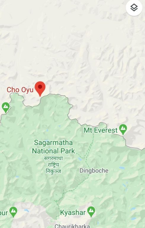
Google Maps, the biggest web mapping service available developed by Google, shows that Mt Everest lies in China’s territory.
‘Mt Everest’ search in Google Earth as of 17 May, 2020 shows the result as Mt Everest in Tibet, China. Google Earth shows coordinates of Mt Everest 27.99N, 86.92 E, which lies in China, and Google Maps also shows Mt Everest in Tingri, Shigatse, Tibet, China.
According to a 1960 Border Resolution Agreement, China and Nepal agreed that the Southern slope of Mt Everest would belong to Nepal and the Northern slope to Tibet, which China claims as a part of its territory.
While most of the social media users have pointed put the wrong placement of Mt Everest, the position of Cho Oyu in Google Maps is also incorrect. The sixth highest mountain of the world, Cho Oyu, has the height of 8201 meters and is situated along Nepal-China border – 20 km west of Mount Everest.
Nepal has eight out of 10 highest peaks in the world, excluding second highest mountain K2 and ninth highest mountain Nanga Parbat.
Google Maps offers satellite imagery, aerial photography, street maps, 360° interactive panoramic views of streets and real-time traffic conditions among other services with billion user every month and more than five million active apps and websites using Google Maps Platform core products every week.
Only a week ago, a Tweet by China’s state-run channel CGTN had courted public wrath for claiming that Mt Everest lies in Tibet – it deleted the Tweet before posing another one with Nepal’s name after several comments and protests by social media users.
Google Maps Product Director, Ethan Russell, has said in FAQ, ” The world is a vast and constantly changing place,” adding, “There are a few different channels for people, businesses, and customers to help update our maps data when something’s not right. Anyone who uses Google Maps can let us know about data issues via the Send Feedback (desktop Maps) and Suggest an Edit (place profiles on Maps and Search) tools.”


