

The National Assembly (NA) yesterday unanimously adopted a parameter, directing the government to intensify the ongoing diplomatic initiative and launch high-level political efforts to resolve Nepal-India border dispute in the Kalapani region.
Proposed by the ruling Nepal Communist Party (NCP) NA Chief Whip Khim Lal Bhattarai and supported by main opposition Nepali Congress NA Chief Whip Sarita Prasain, the stricture also directed the government to take the initiative taken by Nepal-India High-Level Technical Committee on resolving border-related issues to logical conclusion.
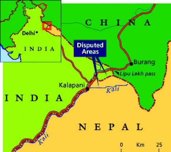
Presenting the stricture in the House, Bhattarai said the entire nation’s attention had been drawn towards the recently-published Indian political map that depicted the Kalapani region comprising Limpiyadhura, Lipulekh and Kalapani as Indian territories.
“As per the international river principle, the Mahakali River’s origin is Limpiyadhura and the region on the eastern side is Nepali territory,” said Bhattarai.
In his reply, Minister of Foreign Affairs Pradeep Kumar Gyawali said Nepal-India borders were determined by the Sugauli Treaty of 4 March 1816 and three other subsequent treaties.
According to Gyawali, the Sugauli Treaty map determined Nepal’s border on the eastern (Mechi River) and western sides (Kali River), whereas the treaty of 8 December 1816 determined Nepal’s borders on the southern side (from Koshi River to Rapti River).
The treaty of 1823 ensured Nepal got back Banke, Bardiya, Kailali and Kanchanpur, and the treaty of 7 January 1875 determined Daduwa watershed of Dang as Nepal-India border.
Gyawali said several maps — Sugauli Treaty-era map, 1827 map prepared by British Survey of India, 1844 Almora map, 1850 Kumaon-Garhwal map and 1856 map — proved that Limpiyadhura was the origin of the Kali River.
He said after the 1950s, India renamed the Kali River as West Kali and designated another river originating from Lipulekh, some 50 km east, as the Kali River. It shifted the border further 17-18 km east by determining another river as Kali River by placing Lipulekh and Kalapani on the western side, added Gyawali.
Gyawali added that Nepal had forwarded a diplomatic note to India on November 20 requesting it to hold dialogue and India responded positively on December 19. “India has acknowledged the problem and has expressed urgency to solve it,” he said.